A capillary of the Silk Road, not a highway
The Silk Road was never a single road — it was a network of arteries and capillaries, and the Hunza corridor was one of the boldest capillaries of all. Branch routes dropped south from the great oasis bazaars of Kashgar and Yarkand in Chinese Turkestan, crossed the high passes of the Karakoram, and threaded the Hunza gorge down to Gilgit, and onward to Kashmir and the plains of India.
It was a brutal shortcut. The main Central Asian caravan roads swung wide around these mountains for good reason: the Hunza route demanded passes near 5,000 metres, cliff paths above a furious river, and rope bridges that made hardened traders pray. But for small, fast parties — pilgrims, message-carriers, smugglers and traders in light, precious goods — it shaved weeks off the journey between the Tarim Basin and the subcontinent.
That traffic ran for roughly two thousand years, and it explains a great deal about modern Hunza: the valley's openness to strangers, the trading instinct of its people, and the layered languages and faiths of the villages you'll walk through between Karimabad and the Khunjerab Pass.
The Sacred Rocks of Hunza: a guestbook in stone
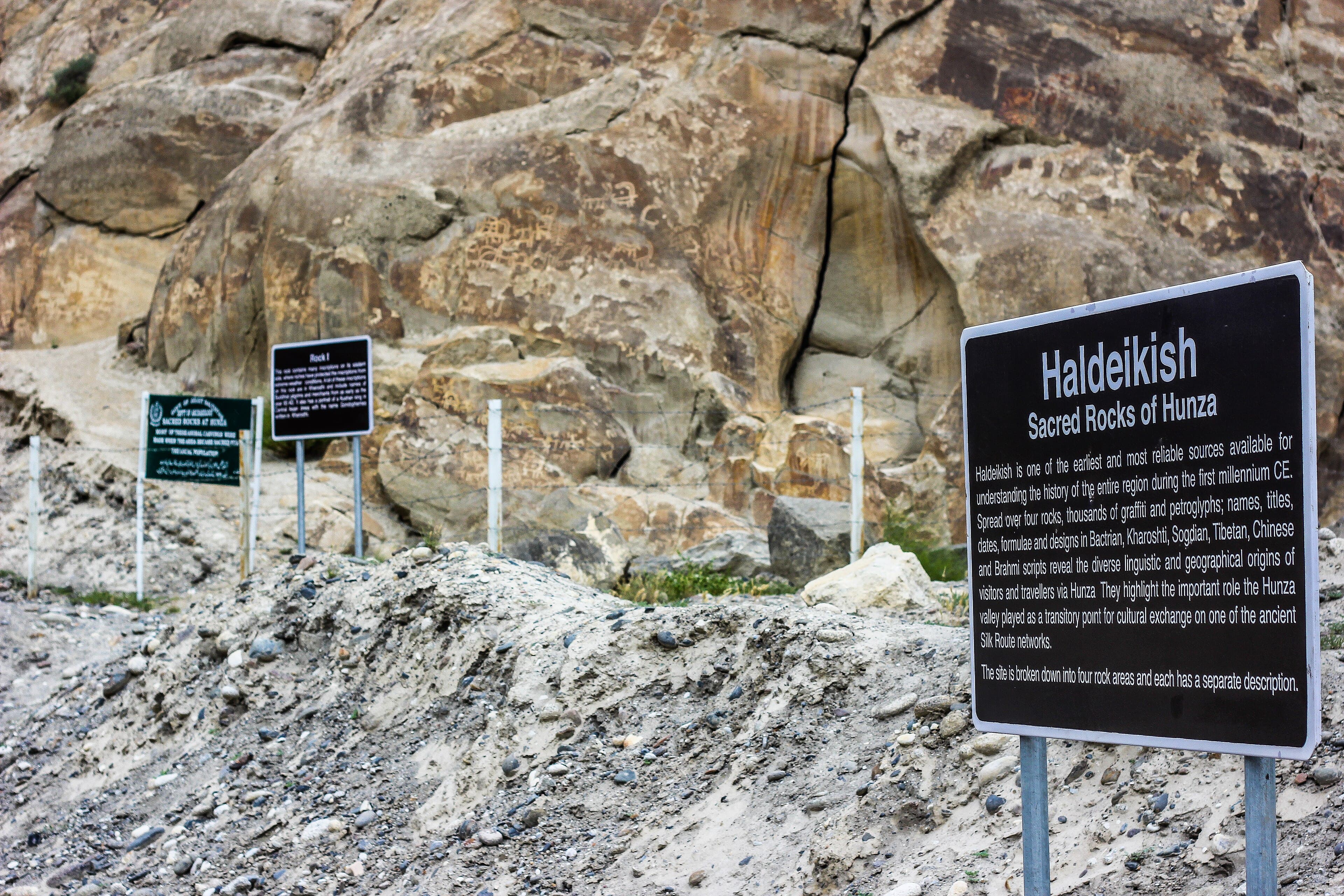
Just east of Ganish village, beside the Karakoram Highway, a cluster of dark boulders rises above the Hunza River. These are the Sacred Rocks of Hunza, known locally as Haldeikish — 'place of the male ibexes' — and they are the valley's most extraordinary historical document. Thousands of petroglyphs and inscriptions crowd their surfaces, left by travelers over some two thousand years.
The oldest images are hunting scenes and long-horned ibex, pecked into the rock varnish by herders and hunters long before written records. Over them, century after century, passing travelers added their names and prayers in Kharosthi, Brahmi, Sogdian, Tibetan and Chinese — a roll call of the scripts of Silk Road Asia. Sogdian merchants from Samarkand, Buddhist pilgrims bound for the monasteries of Gandhara, Tibetan soldiers and Chinese envoys all stopped here and carved proof of their passage.
Standing at Haldeikish today, you're at one of the few places on earth where you can put your eyes a few centimetres from the handwriting of ancient travelers, in the open air, beside the road they used. Visit with a local guide who can pick out individual inscriptions — and never touch or trace the carvings, which are fragile and irreplaceable.
Over the top: Mintaka, Kilik and the old passes
Long before anyone dreamed of the Khunjerab Pass road, the main gates between Hunza and Chinese Turkestan were the Mintaka and Kilik passes, at the head of the Chapursan and Misgar valleys in upper Gojal. These were foot and pony routes: no wheeled vehicle ever crossed them, and caravans were strings of yaks, ponies and porters moving at walking pace.
Mintaka — 'a thousand ibex' in the local tongue — was the more travelled of the two, and for centuries it was Hunza's window on Kashgar and Yarkand. The Mir of Hunza maintained ties with Chinese authorities across these passes, sending gifts and receiving them in return, a relationship Hunza's rulers were happy to describe as friendship and the Chinese court recorded as tribute.
When the Karakoram Highway was planned in the 1960s, engineers initially looked at the Mintaka alignment before settling on the Khunjerab, which offered a gentler gradient for vehicles. The old passes fell silent, and today Mintaka and Kilik sit inside a restricted border zone closed to casual trekkers — but the lower Chapursan Valley, on the approach, is open and remains one of the most atmospheric corners of old Gojal.
What the caravans carried — and who robbed them
The loads that came over the passes were chosen for value per kilogram: Chinese silk and tea, salt, charas, turquoise and gold dust panned from Central Asian rivers, moving south; cotton cloth, spices, sugar and manufactured goods moving north. Hunza itself sold little — the valley was poor in everything except apricots, grit and strategic position — but it taxed, guided and fed the traffic.
It also preyed on it. Through the nineteenth century, Hunza developed a fearsome reputation for raiding the caravan road between Leh and Yarkand, hundreds of kilometres to the east. Raiding parties crossed the Shimshal Pass, swept down on caravans crossing the Karakoram Pass route, and returned with goods and captives; the trade in enslaved captives to Central Asian markets was a dark but real pillar of the old kingdom's economy.
The raids were not mere banditry — the Mirs treated them as state policy and a source of leverage, and they are a large part of why British India eventually decided Hunza had to be brought to heel in 1891. It is a measure of how completely the valley has changed that the descendants of the raiders now run some of the most trusted guesthouses and guide services in Asia.
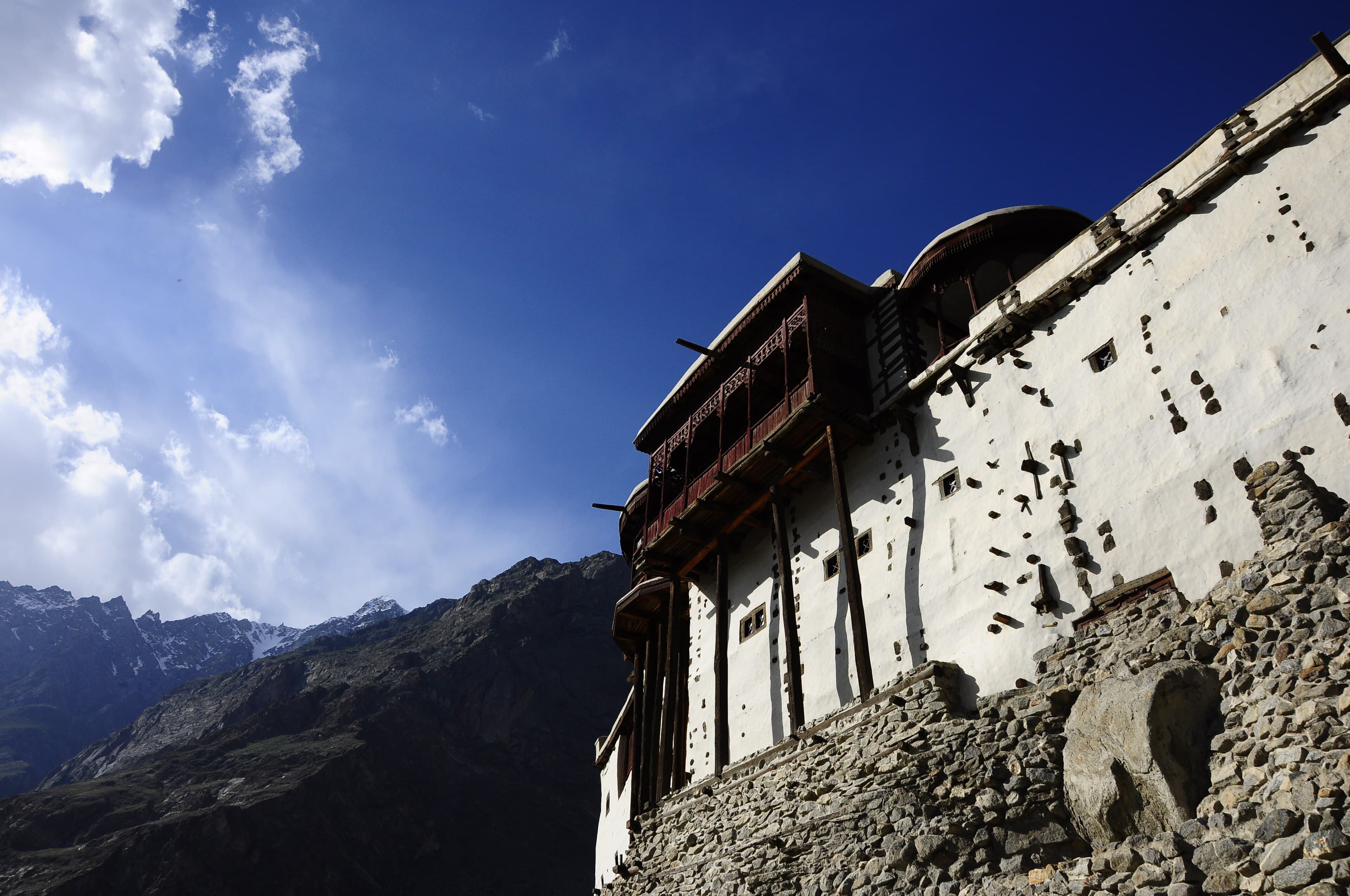
Ganish: the caravan village that watched the road
Where the Sacred Rocks meet the river crossing, the village of Ganish grew up as the first and last caravan stop in central Hunza. It is the oldest settlement on this stretch of the valley floor, and it still looks the part: a tight knot of timber-and-stone houses, ancient carved mosques and watchtowers built around a central pond that once watered animals and fought fires.
The watchtowers tell you what caravan life was really like. Ganish sat exposed to raids from Nagar, just across the river, and the village was built as a fortress — blank outer walls, low entrance tunnels and towers from which defenders could watch the bridge. Families lived inside this defensive shell for centuries, and the restored core, recognised with UNESCO Asia-Pacific heritage awards, can be visited today with village guides.
Walking Ganish's lanes after the Sacred Rocks is the best one-two punch of Silk Road history in Hunza: first the travelers' carvings, then the village that housed, fed and sometimes fleeced them. It's twenty minutes from Karimabad and pairs naturally with Baltit and Altit forts on a heritage day.
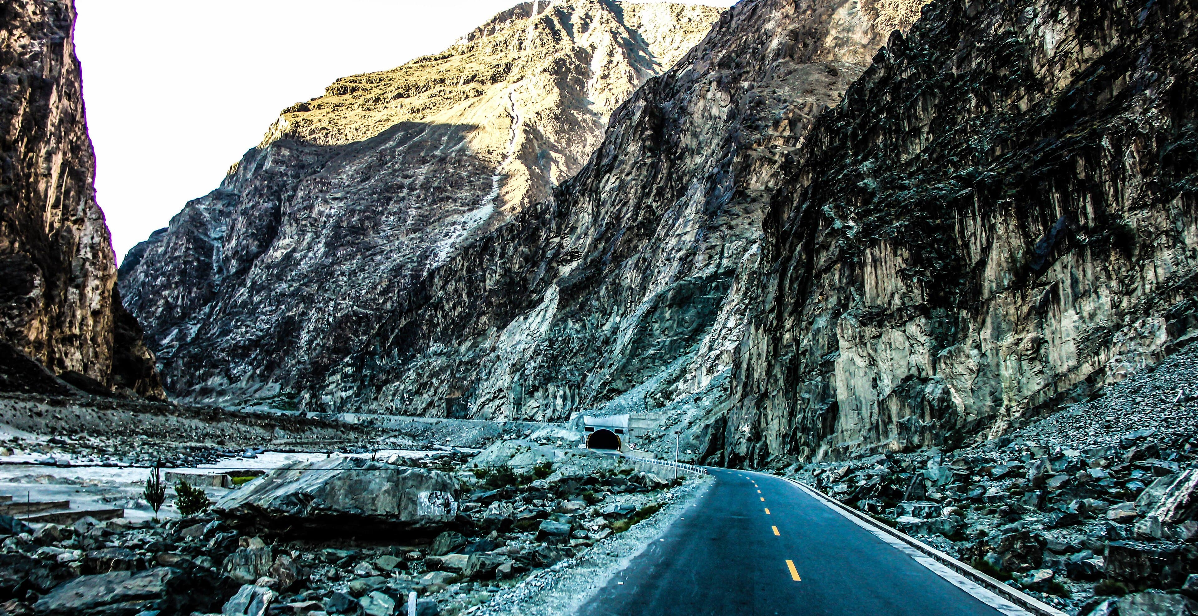
The Karakoram Highway: the Silk Road, paved
When Pakistan and China carved the Karakoram Highway through the gorge — opened to traffic in 1978 after nearly two decades of work — they were not inventing a route, they were paving one. The KKH shadows the old caravan alignments for most of its length, swapping the Mintaka foot-pass for the Khunjerab's 4,693-metre road crossing, the highest paved border crossing in the world.
Driving the highway today is the closest thing to time travel the Silk Road offers. You pass beneath Rakaposhi as the caravans did, squeeze through the same gorge narrows, and stop at Ganish where they camped. The difference is that what took a caravan weeks of dangerous walking now takes a comfortable day's drive from Gilgit to the Chinese border.
The trade never stopped, either — it just changed vehicles. Chinese container trucks now roll down from the Khunjerab to the dry port at Sost, where customs officers process the goods of the new Silk Road; in the bazaars of Sost and Gilgit you'll find Chinese fabrics, thermoses and green tea sitting on shelves exactly as their ancestors' cargo once sat in caravanserais.
Walking pieces of the old road yourself
You can still put your boots on the old trails. The most accessible taste is the path network around Ganish and the Sacred Rocks, and the old village-to-village footpaths of central Hunza that predate the road — local guides in Karimabad can link Altit, Ganish and the river crossing into an easy half-day heritage walk.
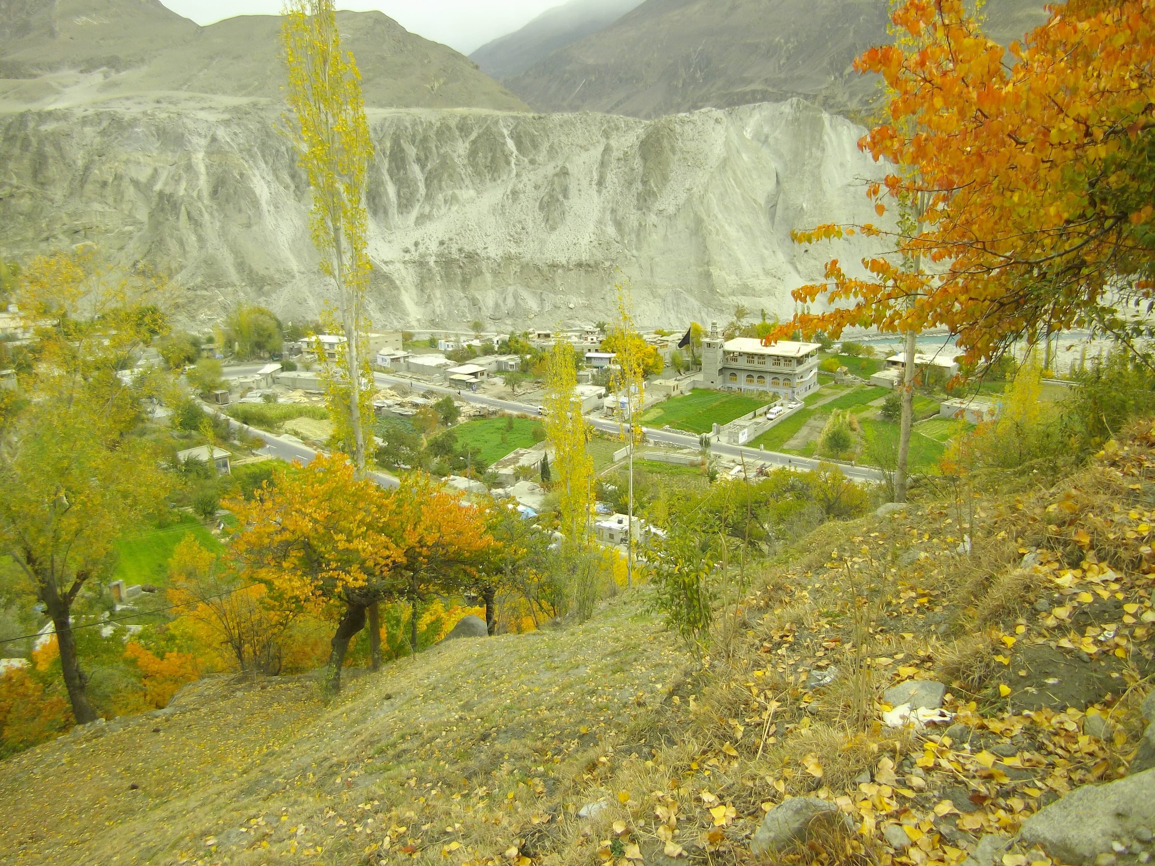
In Gojal, the Chapursan Valley road follows the old Kilik approach past Wakhi villages to the shrine of Baba Ghundi, a pilgrimage site that has watched over travelers for centuries; and the trek toward Shimshal retraces the raiders' corridor in reverse. The Hussaini Suspension Bridge — rebuilt many times — gives you an honest, knee-trembling feel for what river crossings meant before steel cable.
Time it for September or October if you can: autumn light on the gorge, apricots drying on rooftops in Ganish, and the highway quiet between tour seasons. Bring binoculars for the petroglyph panels and a wide lens for the road itself — the Silk Road has never photographed better.
Questions, answered
Was Hunza really part of the Silk Road?
Yes — Hunza carried one of the Silk Road's branch routes, linking Kashgar and Yarkand in Chinese Turkestan with Gilgit and Kashmir. It was a hard, high-altitude shortcut used by traders, pilgrims and envoys for roughly two thousand years, and the inscriptions at the Sacred Rocks of Hunza prove the traffic in five ancient scripts.
What are the Sacred Rocks of Hunza?
The Sacred Rocks, known locally as Haldeikish, are boulders beside the Karakoram Highway near Ganish covered with thousands of petroglyphs and inscriptions in Kharosthi, Brahmi, Sogdian, Tibetan and Chinese. They were carved by travelers over about two thousand years and are free to visit, ideally with a local guide.
Which passes did the old Silk Road caravans use before Khunjerab?
Caravans crossed the Mintaka and Kilik passes at the head of the Misgar and Chapursan valleys — foot and pony routes linking Hunza with Kashgar and Yarkand. The Khunjerab alignment was chosen for the Karakoram Highway in the 1960s because it suited vehicles better, and the old passes now lie in a restricted border zone.
Can you still see Silk Road sites in Hunza today?
Easily. The Sacred Rocks of Hunza, the fortified caravan village of Ganish, Baltit and Altit forts and the Karakoram Highway itself are all living pieces of the route. The Chapursan Valley and the Hussaini Suspension Bridge give a feel for the old trails, and border trade still flows through Sost below the Khunjerab Pass.
Is it true that Hunza raided Silk Road caravans?
It is. In the nineteenth century, raiding parties from Hunza crossed the Shimshal Pass to plunder caravans on the Leh–Yarkand road, and the Mirs treated raiding as state policy. The practice helped trigger the British campaign of 1891 that ended Hunza's independence.