The road that shouldn't exist
The Karakoram Highway — the KKH, or N-35 — is the highest paved international road in the world, running roughly 1,300 km from Hasan Abdal near Islamabad to Kashgar in China over the 4,693 m Khunjerab Pass. Built jointly by Pakistan and China between 1959 and 1979, it took two decades, claimed the lives of around a thousand workers — commemorated at monuments along the route — and earned its nickname: the Eighth Wonder of the World.
What makes it extraordinary isn't just the engineering; it's the geography it unlocks. The KKH traces the ancient Silk Road through the collision zone of three great ranges — Himalaya, Karakoram and Hindu Kush — passing within sight of Nanga Parbat (8,126 m) and Rakaposhi (7,788 m), skirting a lake that drowned the old road, and finally cresting a pass where ibex graze beside the China border gate.
For travellers, the Pakistani section from Islamabad to Khunjerab (about 870 km) is the road trip. It's fully paved, driven daily by buses and family cars, and lined with guesthouses, fuel stops and some of the most hospitable communities in Asia.
Route overview: the five stages
Stage one, Islamabad to Besham (about 270 km, 6–7 hrs) or alternatively via Naran: motorway and hill roads through Abbottabad and the Hazara region. In summer (roughly July–September) many travellers take the far more scenic alternative through the Kaghan Valley — Naran, Lake Saif-ul-Malook and the 4,173 m Babusar Pass — rejoining the KKH near Chilas.
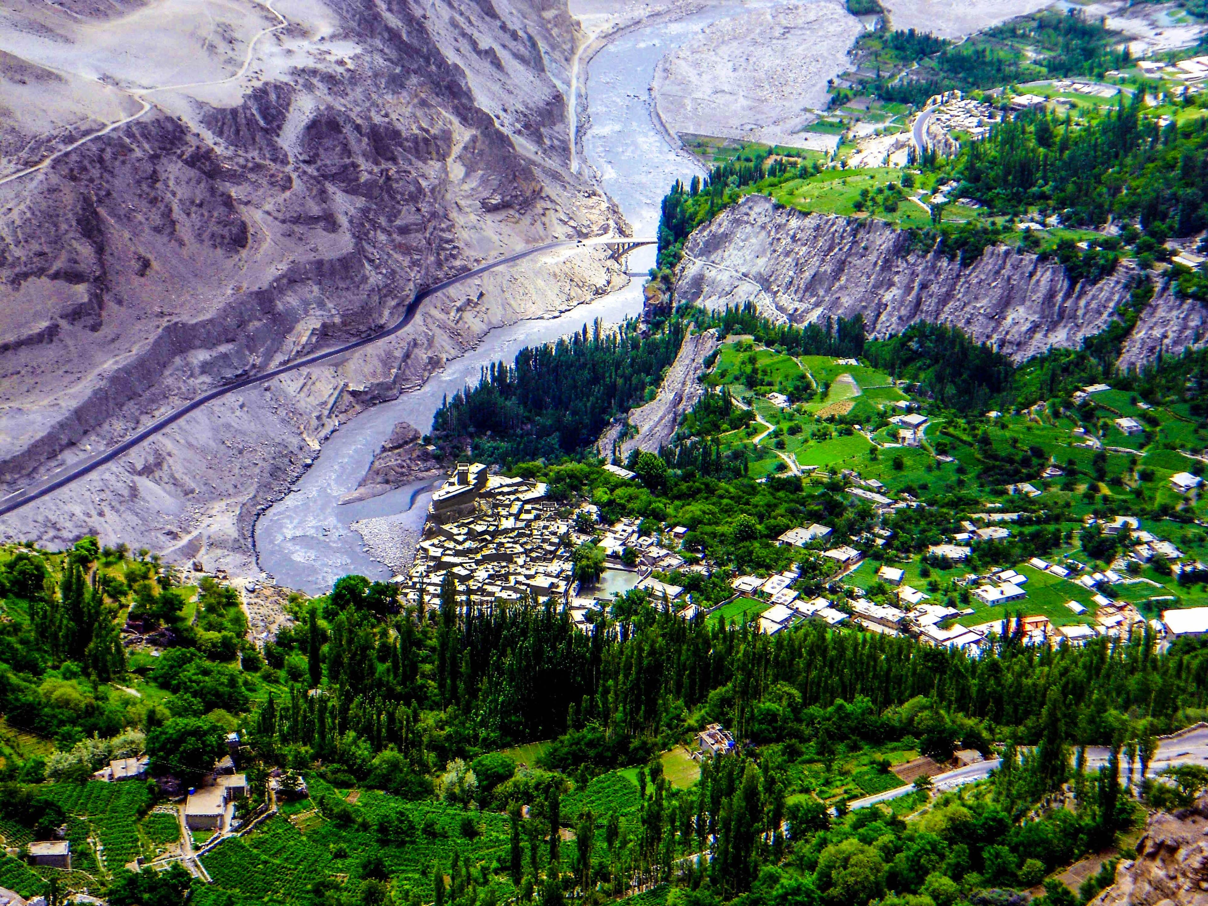
Stage two, Besham to Chilas (about 200 km, 5–6 hrs): the wild Indus gorge section, where the road clings to rock faces above the river — slower going and best done in daylight. Stage three, Chilas to Gilgit (around 130 km, 3 hrs): the gorge opens up, and you pass two unmissable viewpoints — Nanga Parbat from the Thalichi/Raikot stretch, and the Three Mountain Ranges junction point near Jaglot where the Indus meets the Gilgit River.
Stage four, Gilgit to Hunza (about 100 km, 2.5 hrs): the highway's glamour stretch, with Rakaposhi filling the windscreen at the famous Rakaposhi View Point cafés. Stage five, Karimabad to Khunjerab Pass (about 180 km, 4–5 hrs one way): through the Attabad tunnels, past Gulmit, the Passu Cones and Sost (the last town), then hairpins up through Khunjerab National Park to the border gate at 4,693 m.
Road conditions and what to drive
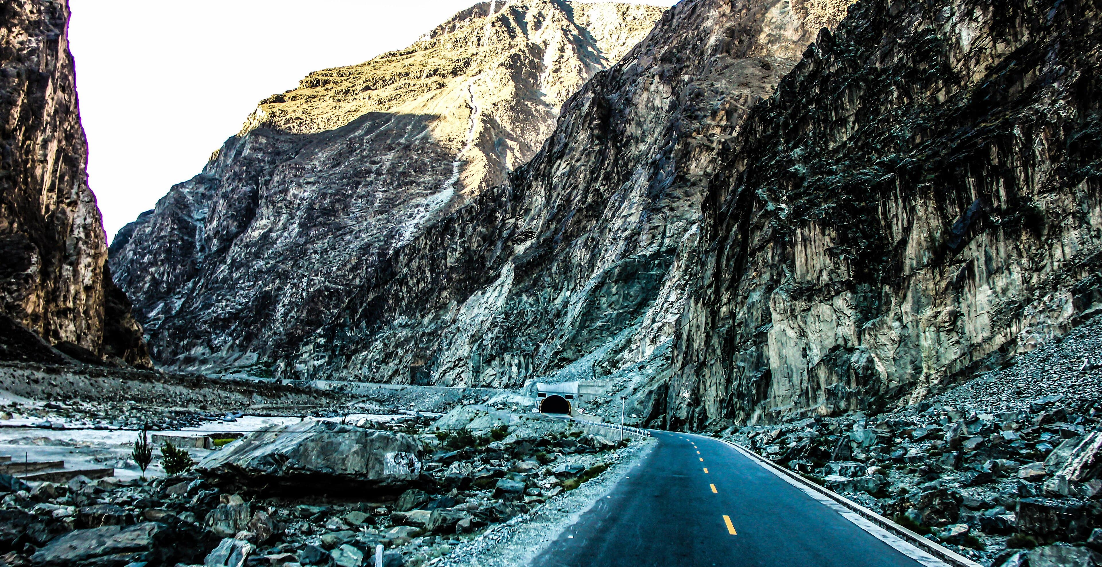
The KKH is asphalted end to end and generally in good condition — Chinese-led rebuilding after the 2010 Attabad disaster left the Gilgit–Khunjerab section, including five kilometres of tunnels, as smooth as any alpine road in Europe. The rougher patches are in the Indus gorge between Besham and Chilas, where rockfall scars and roadworks appear and disappear season to season.
Landslides are the KKH's weather: occasional, usually cleared within hours by stationed machinery, and the reason every good itinerary carries a buffer day. Fuel is available in all main towns (fill up at Gilgit, Aliabad and Sost heading north), and mobile coverage is decent along the populated stretches — see our packing guide for the SIM card details.
You don't need a 4x4 for the KKH itself; any well-maintained car makes it, and the road carries everything from motorbikes to Bedford trucks in full regalia. You do need a 4x4 for the famous side trips — the Fairy Meadows jeep track, Deosai, and valley roads like Hopper Glacier's approach. Most international visitors take a car with a local driver: affordable, and the driver doubles as fixer, translator and landslide-intelligence service. Self-driving and motorbiking are possible for the experienced; ride defensively and never at night.
The stops that make the trip
Don't drive the KKH as a transit corridor — its genius is in the stops. South to north, the essentials: the Three Ranges junction viewpoint near Jaglot; the Nanga Parbat viewpoint at Thalichi; Raikot Bridge, the jump-off for Fairy Meadows; Rakaposhi View Point at Ghulmet, where you drink chai beneath a 7,788 m wall of ice; and Karimabad, where Baltit and Altit Forts deserve a full day.
North of Karimabad the hits come fast: the Attabad tunnels and the impossibly turquoise Attabad Lake; Gulmit's old village; the Hussaini Suspension Bridge, the planet's most photographed scary footbridge; the cathedral-spired Passu Cones; and Borith Lake with the Passu Glacier walk above it. Finally Khunjerab Pass itself — go early, carry warm layers and your passport, and watch for ibex, yaks and golden marmots inside the national park.
Two detours justify extra days: Fairy Meadows (two days minimum, for the Nanga Parbat Raikot face) and the Skardu road east to Baltistan, which turns a KKH run into a grand circuit. Eagle's Nest at Duikar, above Karimabad, is the sunset stop — arguably the single best roadside panorama in Pakistan.
How many days do you need?
The honest minimum is five days Islamabad to Khunjerab and back, but it's a sprint that spends most waking hours driving. Seven days is the comfortable classic: two days up (overnighting Besham or Naran, then Karimabad), three days exploring Hunza and the Khunjerab day trip, two days back with an overnight in Chilas. This is essentially the shape of our 7-day Hunza itinerary.
Ten to fourteen days is where the KKH becomes the trip of a lifetime: add Fairy Meadows (2 days), Skardu and Baltistan via the Indus gorge road (3–4 days), and unhurried time in upper Hunza. Photographers should weight extra nights at Karimabad and Passu, where the light changes everything between dawn and dusk.
Season notes: the full road trip works April–November; July–September adds the Babusar Pass option and Deosai; October trades high-pass certainty for the greatest autumn colour. Whatever your span, structure drives so the gorge sections fall in daylight, and keep your last day before any international flight free.
Practicalities: checkpoints, money and where to sleep
Foreigners register at a series of police checkpoints — at Besham, Chilas, and entering Gilgit-Baltistan, among others. It's routine and friendly: keep your passport handy and carry a stack of photocopies of your passport and visa to hand over, which turns each stop into a two-minute affair.
Cash strategy matters: ATMs are dependable in Islamabad, Besham, Chilas and Gilgit, patchier in Aliabad and Karimabad, and effectively absent beyond. Withdraw what you need for upper Hunza before leaving Gilgit. Accommodation along the route runs from simple highway hotels in Besham and Chilas to excellent guesthouses and boutique heritage stays in Karimabad and Gulmit — book ahead for June–August and October.
Crossing into China over Khunjerab is possible when the border is open (roughly April–November) with a Chinese visa arranged in advance, but most travellers treat the pass as a turnaround point: stand at the gate, photograph the marker at 4,693 m, share the moment with the marmots, and roll back down into Hunza for apricot cake.
Questions, answered
How long does it take to drive the Karakoram Highway?
Islamabad to the Khunjerab Pass is about 870 km and 20+ hours of pure driving, so the realistic minimum round trip is five days. Seven days is the comfortable classic, and 10–14 days lets you add Fairy Meadows and Skardu.
Is the Karakoram Highway dangerous to drive?
The KKH is fully paved and driven daily by ordinary cars and buses; the Gilgit–Khunjerab section is in excellent condition. The genuine risks are occasional landslides and the winding Indus gorge stretch — managed by driving in daylight, keeping a buffer day, and using an experienced local driver.
When is the Karakoram Highway open?
The highway itself stays open year-round at valley level, but the Khunjerab Pass closes roughly December–March and the Babusar Pass alternative only opens around July–September. April to November is the practical road-trip season.
Who built the Karakoram Highway and when?
Pakistan and China built it jointly between 1959 and 1979, cutting through the collision zone of the Himalaya, Karakoram and Hindu Kush. Around a thousand workers died during construction, and the road is often called the Eighth Wonder of the World.
Do I need a 4x4 for the Karakoram Highway?
No — the KKH is paved end to end and any well-maintained car can drive it. You only need a 4x4 (with a local driver) for side trips like the Fairy Meadows jeep track, Deosai National Park and rough valley roads.