Why trekkers call this the greatest walk on Earth
No other trek delivers what the Baltoro does: a two-week walk that ends standing beneath K2, the world's second-highest mountain, having passed the Trango Towers, Masherbrum, Gasherbrum IV and Broad Peak along the way. At Concordia, four of the planet's fourteen 8,000-metre peaks stand within a few kilometres of your tent.
It is also a journey through mountaineering history. You walk the same stages as the 1909 Abruzzi expedition and the 1954 Italians who first climbed K2, and you end at the Gilkey Memorial, where the names of those who never came down are hammered into tin plates above the glacier.
Be clear-eyed about what you're signing up for, though. This is a strenuous expedition-style trek — around 12 to 14 trekking days of camping, with no villages, no teahouses and no exit shortcuts once you're on the glacier. The reward is proportional to the commitment.
Skardu to Askole: the jeep ride in
The trek begins with one of the world's great drives: six to eight hours by 4x4 from Skardu through the Shigar Valley and up the Braldu gorge to Askole, the last village, at roughly 3,000 metres. The track clings to cliffsides above the churning Braldu River and is an adventure in its own right.
Askole is where your trekking team assembles — guide, cook and the porters who will carry the expedition's food, fuel and tents. Watching loads being weighed and assigned in the morning chaos is your first taste of the Baltoro's working culture, essentially unchanged for a century.
Most itineraries spend a night here before walking, which also helps acclimatization after the jump from Skardu's 2,230 metres.
Askole to Paiju: river plains and the first granite
The first two stages cross hot, surprisingly barren river flats — Askole to Jhola, then Jhola to Paiju — covering long distances of 15 to 20 kilometres a day on good trails beside the Braldu and Dumordo rivers. Start early; the gorges trap heat by midday.
Paiju, a green terrace with trees and running water at about 3,400 metres, is the last true oasis and the traditional rest-day camp. From here the Trango Towers and the snout of the Baltoro Glacier fill the view ahead, and rest-day evenings traditionally end with the porters' singing and drumming.
The extra night at Paiju matters physiologically: above this point you gain altitude steadily on ice, and the bodies that struggle later are usually the ones that rushed this stage.
Onto the glacier: Paiju to Khoburtse and Urdukas
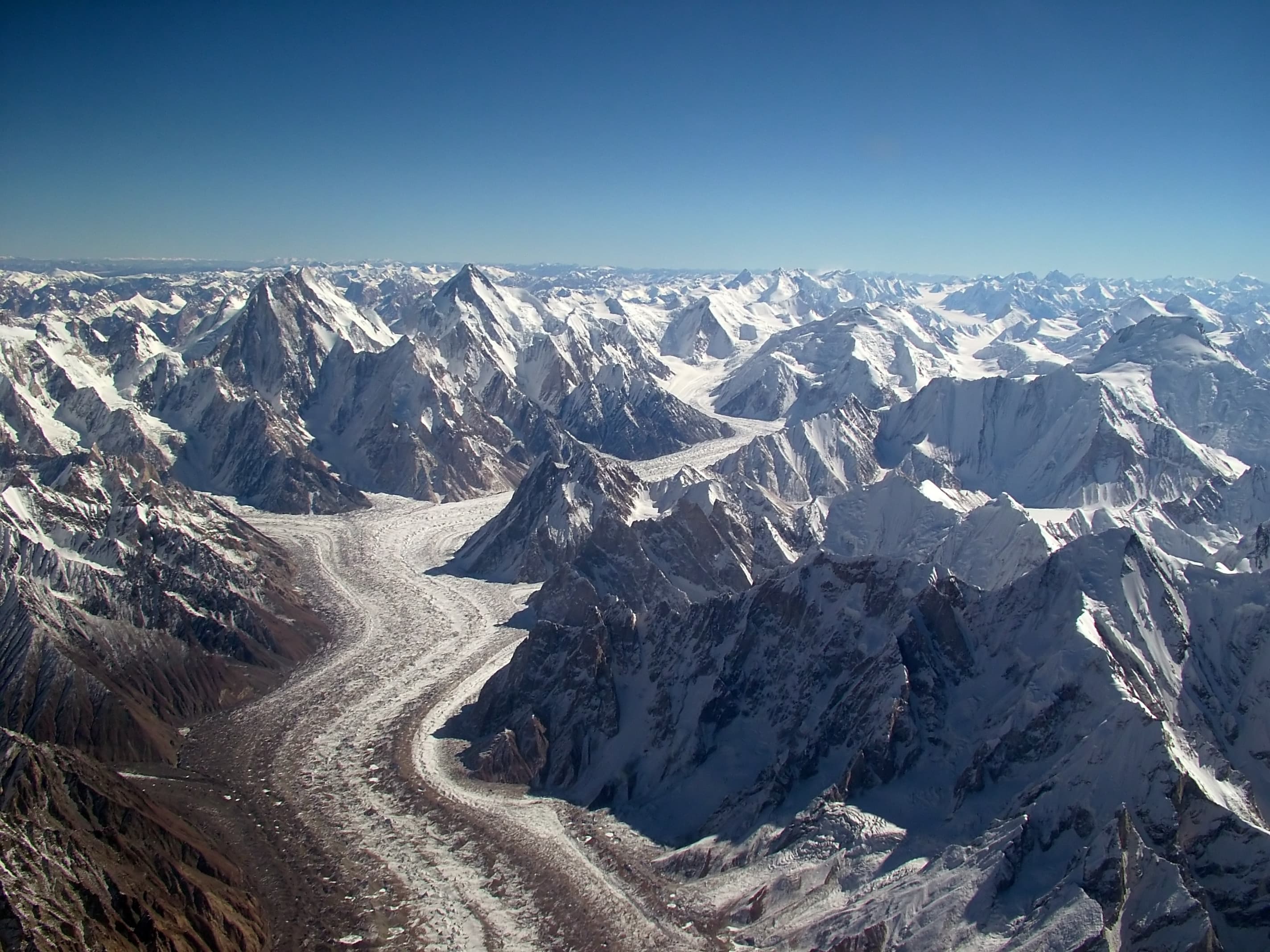
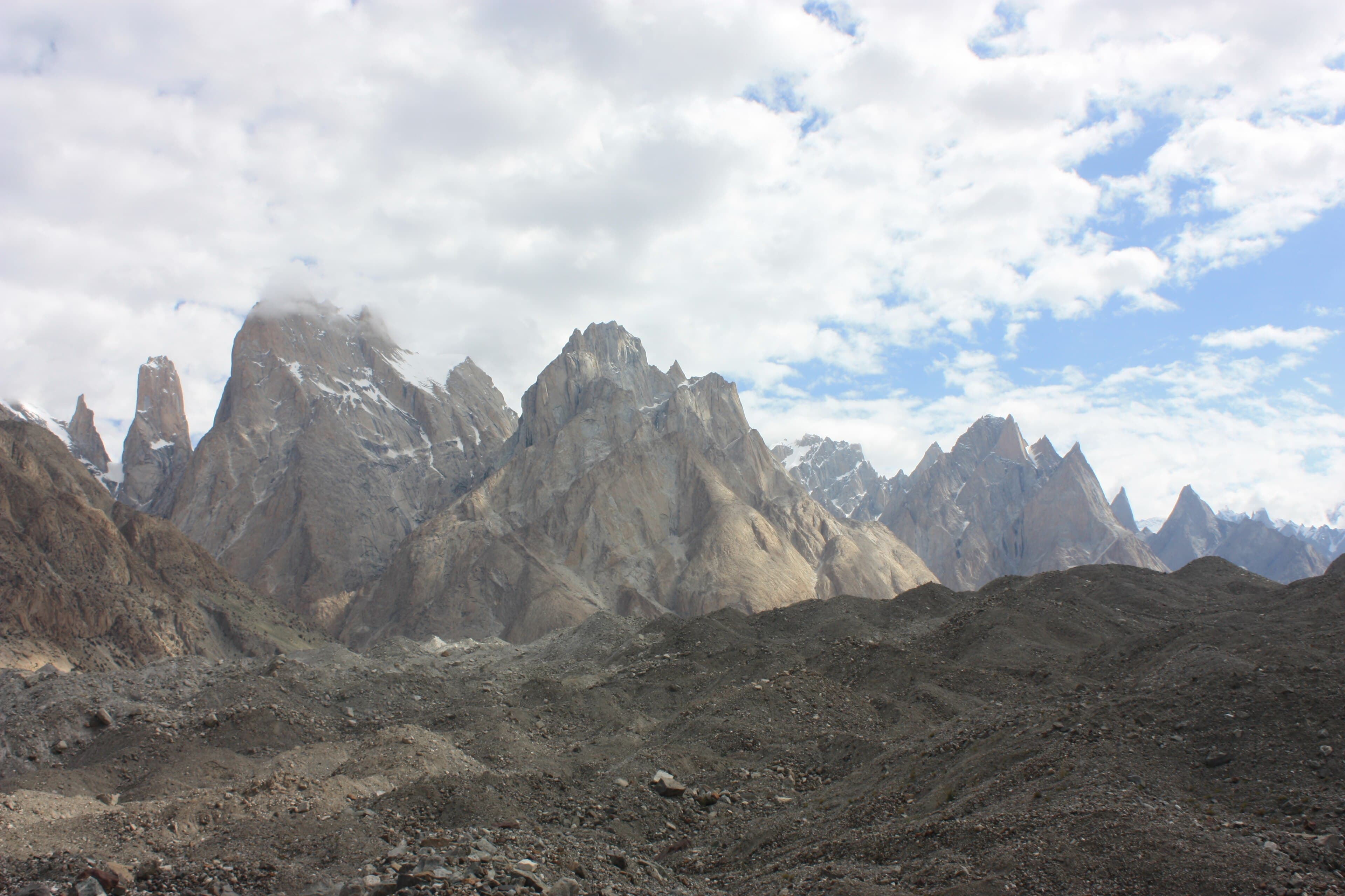
Beyond Paiju you step onto the Baltoro Glacier itself — not the white ice of imagination but a chaotic brown ocean of rock-covered ice, riven with streams and moraine ridges. The trail to Khoburtse and on to Urdukas undulates constantly; daily distances shrink to 8 to 12 kilometres, but every kilometre is earned.
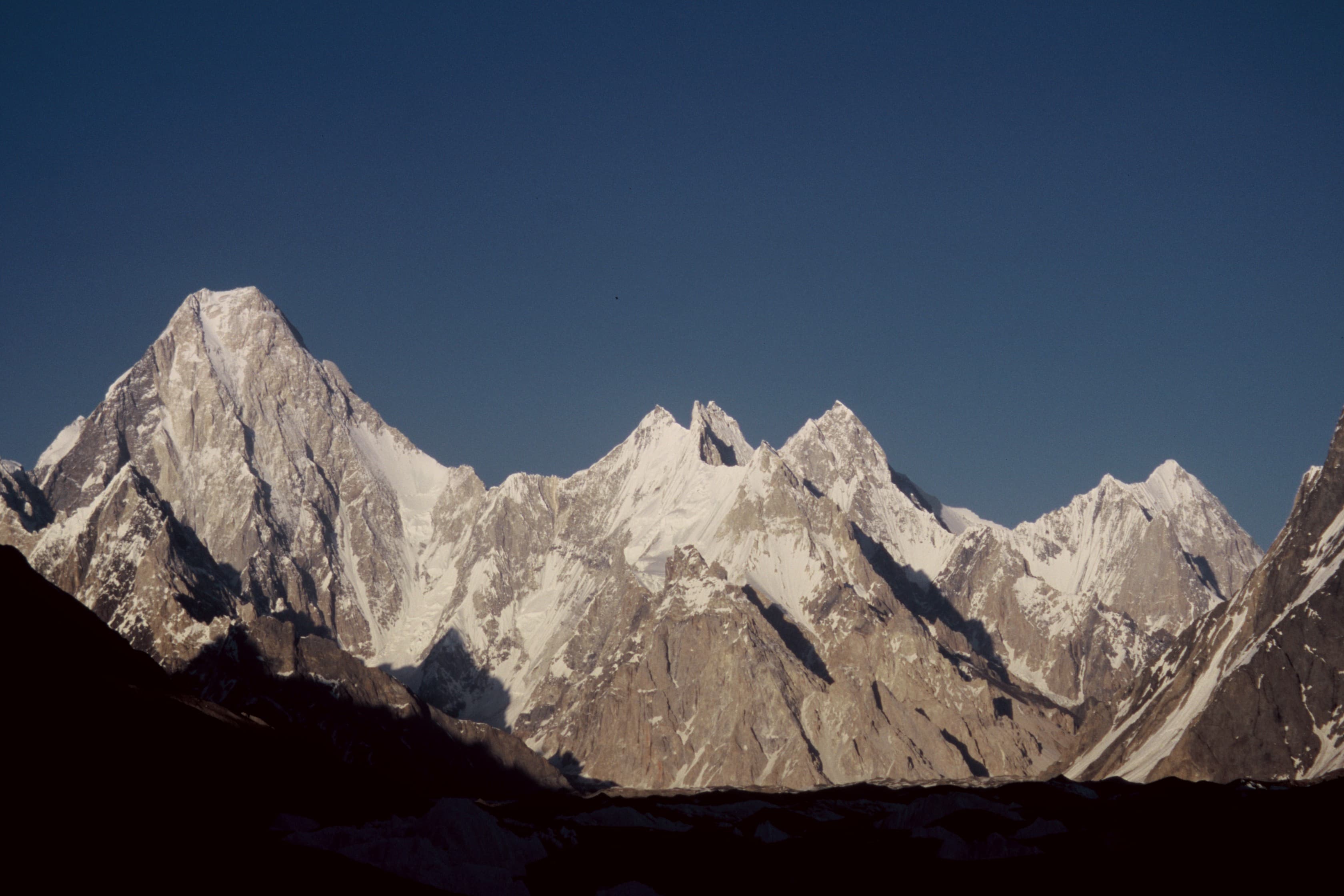
The scenery, meanwhile, detonates. The Trango group and the Cathedral spires rise directly across the glacier — the greatest concentration of big granite walls on Earth — and Masherbrum appears to the south. Urdukas, set on grassy ledges 100 metres above the ice at roughly 4,000 metres, is the most beautiful campsite of the trek and the last grass you will see for a week.
From here on, weather rules everything. Clear spells bring ferocious glacier glare; storms bring snow even in August. Flexibility — a spare day in the schedule — is what separates comfortable parties from miserable ones.
Goro II to Concordia: the throne room of the mountain gods
Above Urdukas the camps sit directly on the ice. Goro II, at roughly 4,300 metres, is a cold camp mid-glacier where Gasherbrum IV's silver wedge begins to dominate the head of the valley — the peak that funnels you onward like a gunsight.
Then comes the day every trekker remembers: the walk to Concordia, where the Godwin-Austen Glacier sweeps in from the north and K2's colossal pyramid swings into view, rising more than 3,000 metres from the ice to its 8,611-metre summit. The American photographer Galen Rowell called Concordia the throne room of the mountain gods, and standing in it, the phrase feels like plain description.
Concordia camp, at about 4,600 metres, is encircled by K2, Broad Peak, the Gasherbrums and Mitre Peak. Most itineraries give it two nights — sunrise and sunset here justify the entire trek.
Concordia to K2 Base Camp and the Gilkey Memorial
From Concordia a long day's round trip — or an overnight at Broad Peak Base Camp — leads up the Godwin-Austen Glacier to K2 Base Camp at roughly 5,000 metres, the tent city from which all K2 expeditions launch. In July you may walk among the expeditions themselves, sharing tea with climbers waiting on a weather window.
On a moraine ridge above base camp stands the Gilkey Memorial, begun in 1953 for the American climber Art Gilkey and now layered with plates and plaques for the many who have died on K2, including Muhammad Ali Sadpara. It is a sobering, deeply moving place, and trekkers should treat it with the quiet it deserves.
The mountain from its own base camp is almost too large to process — you tip your head back and the summit pyramid keeps going. This is the turnaround point of the standard trek; from here, you either retrace the Baltoro or cross the Gondogoro La.
The Gondogoro La exit to Hushe
Fit, acclimatized parties can exit via the Gondogoro La, a roughly 5,600-metre glaciated pass that drops into the Hushe Valley and turns the out-and-back into a traverse. From Ali Camp the crossing starts around midnight: several hours of steep snow on fixed ropes to the crest, then a long, careful descent on scree and snow toward Khuspang.
The summit-line panorama at dawn — K2, Broad Peak, the Gasherbrums and Laila Peak's impossible spear — is regarded by many as the single finest viewpoint in the Karakoram. A dedicated local team fixes ropes and assists crossings in season, but you need crampons, an ice axe, a harness and basic competence with all three.
The reward beyond the view is the descent into a softer world: the pastures and villages of the Hushe Valley, apricots and homestay hospitality, and a jeep out via Khaplu rather than a week's walk back down the glacier. The pass is weather-dependent, and good operators always hold a return-by-Baltoro plan in reserve.
Difficulty, season and training: an honest assessment
Strenuous is the honest grade. There is nothing technical on the standard route — no ropes, no climbing — but you will walk 12 to 14 days at altitudes between 3,000 and 5,000 metres, on rough moraine that punishes ankles, sleeping in tents in temperatures that drop well below freezing. Altitude, cold, glacier glare and sheer accumulated fatigue are the real adversaries.
The season is mid-June to early September, with July and August the reliable core. Outside that window, river crossings, snowed-up camps and cold make the trek a different and far more serious proposition.
Train like it matters: months of hiking with a pack, back-to-back long days, hills or stairs, and general aerobic fitness. The trek breaks people who assumed gym fitness would translate; it rewards people who did long days on rough ground with weight.
Costs, logistics and trekking the Baltoro responsibly
Expect organized treks to cost in the low-to-mid thousands of US dollars per person, varying with group size, the Gondogoro La option and service level. That price should include the trekking permit and Central Karakoram National Park fee, licensed guide, cook and porters, all camping gear and food on trek, and jeep transfers between Skardu and the roadheads — our K2 Base Camp & Concordia trek runs on exactly this model. International flights, Islamabad hotels, personal gear and tips are on you.
Choose your operator on ethics as much as price. Ask how porters are paid, insured, fed and equipped; the difference between a fair operator and a cheap one is carried on other men's backs.
And carry your weight environmentally: the Baltoro's camps have suffered decades of expedition waste, and clean-up initiatives are slowly winning the fight. Pack out what you bring, insist your team does the same, and leave the throne room as you found it.
Questions, answered
How hard is the K2 Base Camp trek?
It's graded strenuous — harder than Everest Base Camp by most accounts. You camp throughout, walk 12 to 14 days on rough glacier moraine between 3,000 and 5,000 metres, and there are no villages or teahouses after Askole. No technical climbing is involved on the standard route, but excellent fitness is essential.
How long does the K2 Base Camp trek take?
Plan on around 12 to 14 trekking days, plus jeep days between Skardu and Askole and buffer days for weather — roughly three weeks door to door from Islamabad. Adding the Gondogoro La crossing to Hushe keeps a similar duration but turns the route into a traverse.
How much does the K2 Base Camp trek cost?
Most organized treks fall in the low-to-mid thousands of US dollars per person, depending on group size and whether the Gondogoro La is included. That typically covers permits, park fees, a licensed guide, cook, porters, tents, food on trek and jeep transfers; flights, hotels in the cities and tips are extra.
Do you need climbing experience for K2 Base Camp?
Not for the standard out-and-back trek — it's a walk on glacier moraine with no ropes or technical ground. The optional Gondogoro La exit is different: it involves fixed ropes, crampons and an ice axe, so you need basic familiarity with that equipment and solid acclimatization.
When is the best time to trek to K2 Base Camp?
July and August are the prime months, within an overall season of mid-June to early September. This is also expedition season, so you'll share the trail and base camps with climbers attempting K2, Broad Peak and the Gasherbrums.