A region photographed before it was reachable
Few remote places on earth have a photographic record as deep as the Karakoram's. Heavy glass-plate cameras were hauled over its passes decades before any motor road existed, carried by survey parties, political officers and expedition photographers who understood they were documenting a world few outsiders would ever see.
The result is a century-long visual archive of Hunza, Baltistan and the great peaks: forts before restoration, rope bridges of twisted twigs, caravans on trails now drowned by the highway, and mountain photographs so precise that climbers still consult them. For travelers with any feeling for history, the old images transform the trip — you start seeing the valleys in double exposure, then and now.
This guide walks through who made the archive — from Great Game surveyors to Vittorio Sella and the Lorimers — what the photographs show, and where you can see them today, in the valley and online.
Surveyors and the Great Game lens
The earliest photographs of the region came with empire. From the late nineteenth century, British survey parties, military expeditions and political missions carried cameras alongside theodolites, and the 1891 Hunza-Nagar campaign and its aftermath were photographed by participants — images of stone forts, levies and durbars that ended up in regimental albums and London archives.
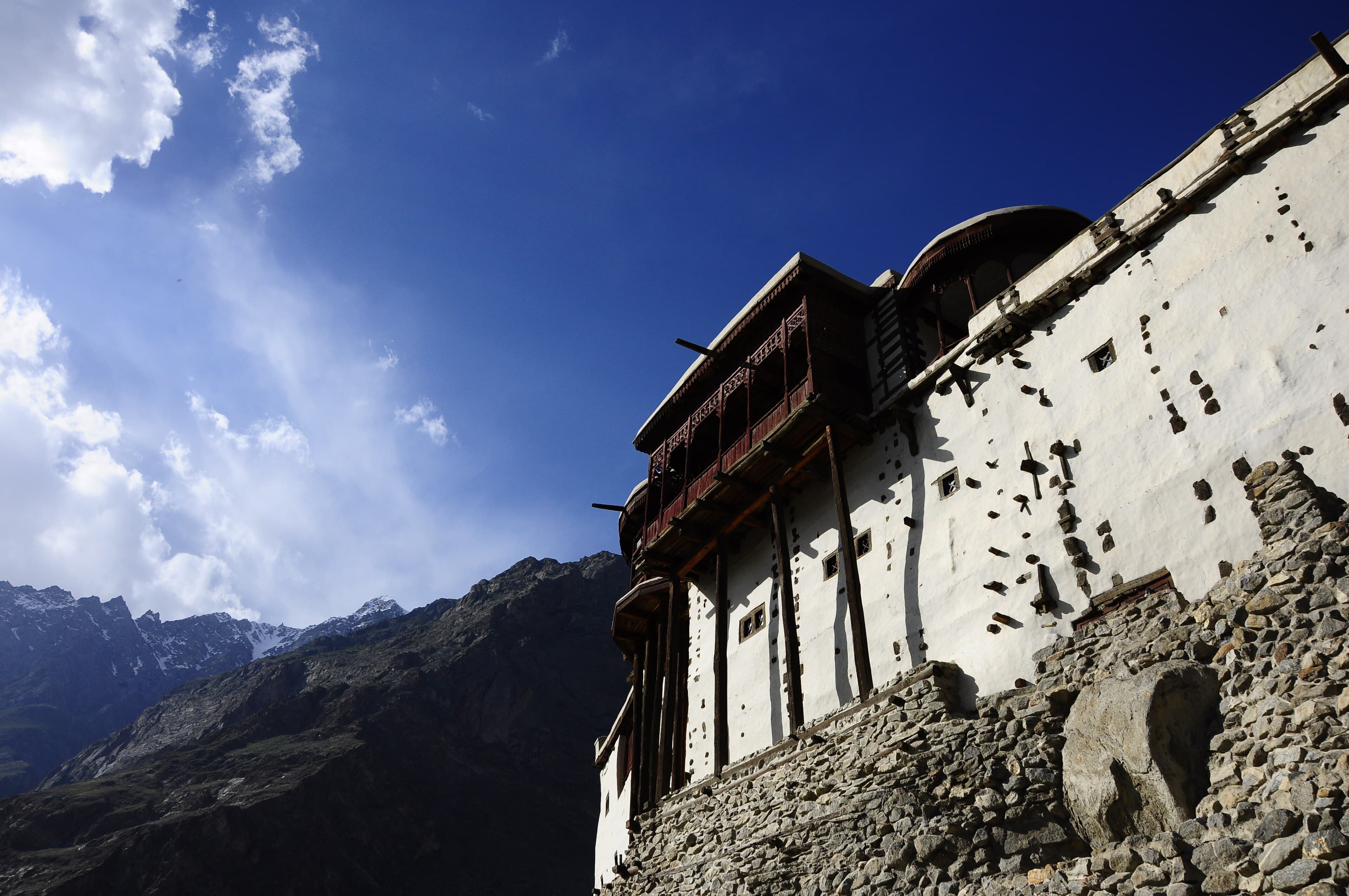
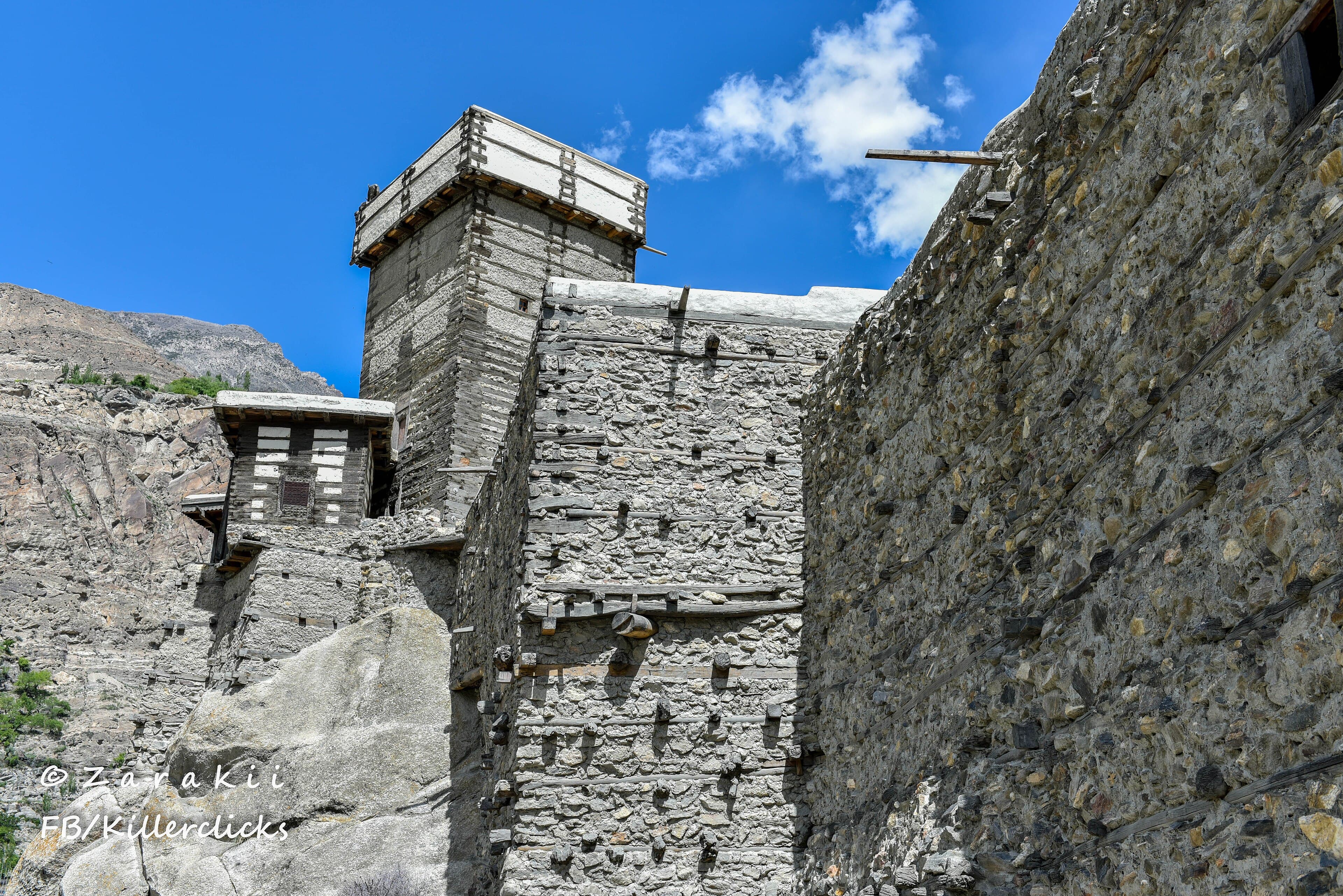
Officers and visitors of the early 1900s added portraits of the Mirs of Hunza and Nagar in ceremonial dress, panoramas of Baltit Fort above the old village, and records of the rope bridges and cliff galleries of the pre-road trails. Much of this material now sits in institutions such as the British Library's India Office collections and the Royal Geographical Society in London.
These photographs were instruments of intelligence as much as art — knowing the passes was the whole point of the Great Game — but viewed today they are something gentler: the first mirror the valleys ever had.
Vittorio Sella and the 1909 K2 expedition
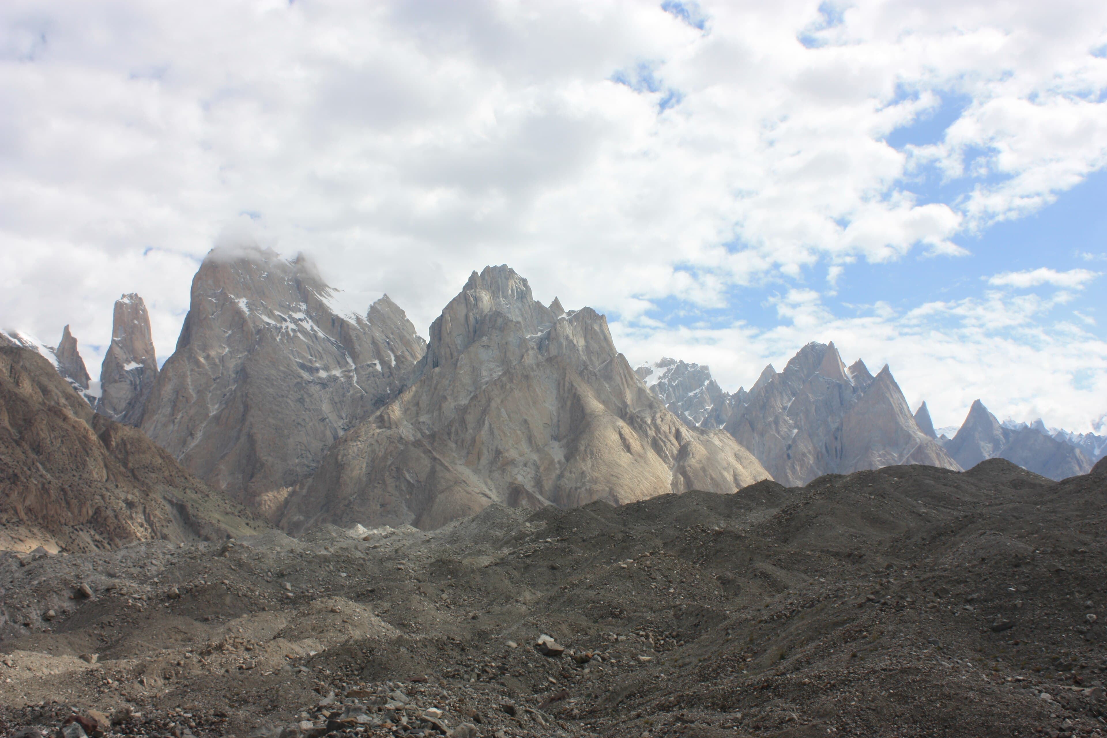
The artistic summit of early Karakoram photography belongs to Vittorio Sella, the Italian master who accompanied the Duke of the Abruzzi's 1909 expedition to K2 and the Baltoro Glacier. Working with large-format cameras and glass plates in brutal conditions, Sella produced images of K2, the Gasherbrums and Concordia of such technical perfection that they remain benchmarks of mountain photography more than a century later.
His photographs were not just beautiful — they were useful. Expedition planners studied Sella's prints for decades; the 1954 Italian team that finally climbed K2 pored over his 1909 images of the ridges, and climbers and glaciologists still compare today's ice levels against his plates. Ansel Adams himself wrote admiringly of the 'religious awe' Sella's mountain work inspired.
The expedition also fixed names and measurements across the upper Baltoro, and the duke's altitude record attempt on Chogolisa set a mark that stood for years. For travelers, Sella matters because his tripod positions — Concordia, Urdukas, the Baltoro's bends — are stages on today's K2 Base Camp trek, and standing in them with his images in mind is one of trekking's great time-travel moments.
The Lorimers: photographing everyday Hunza
If Sella photographed the peaks, David and Emily Lorimer photographed the people. David Lorimer served as British Political Agent in Gilgit in the early 1920s, and returned with Emily to live in Hunza in the mid-1930s for a long stay devoted to scholarship: he was the great early documenter of Burushaski, Hunza's language isolate, publishing the foundational grammar and texts of the language.
Their cameras worked alongside their notebooks. The Lorimers photographed daily life in Aliabad, Baltit and the villages — ploughing and threshing, spinning, festivals, children, fort interiors still in royal use — building one of the most intimate records of any Himalayan community of that era. Emily's warm, observant book 'Language Hunting in the Karakoram' (1939) narrates that stay and remains the classic traveler's-eye account of 1930s Hunza.
The Lorimer material — photographs, recordings and papers — survives in British archives and has been drawn on by researchers and exhibitions in Hunza itself. Read Emily before your trip if you can: walking Karimabad's lanes with her descriptions in your head collapses ninety years in a paragraph.
Expedition films and the golden-age summit shots
The mid-twentieth century put the Karakoram on film as well as plates. Expeditions of the 1930s through 1950s — American attempts on K2 in 1938, 1939 and 1953, the 1954 Italian success, and the Austro-German efforts on Nanga Parbat culminating in Hermann Buhl's astonishing 1953 solo summit push — all carried cameras, and their images became the iconography of mountaineering's golden age.
Some frames entered legend: the 1954 summit photographs from K2, Buhl's haggard portrait after his Nanga Parbat ordeal, and the expedition documentaries that played in European cinemas, including the Italians' official K2 film. These pictures fixed the Karakoram in the world's imagination as the wildest of mountain ranges — a reputation Hunza and Skardu's tourism still draws on.
The same rolls of film captured the approach marches through a vanished world: expeditions walking for weeks from Srinagar or up the Indus gorge, hiring hundreds of Balti porters at Askole, crossing rope bridges with crates of oxygen. The approach photographs are often more historically precious than the summit shots.
What the old images show — and what has changed
Lay the archive beside today's valley and the continuities leap out first. The terraced field systems of Hunza in Lorimer-era frames are the same terraces you photograph from Eagle's Nest at Duikar; Baltit and Altit forts stand on the same skylines; the poplar lanes, irrigation channels and threshing floors of many villages would be instantly navigable by a 1930s ghost.
The differences are just as telling. The forts in old photographs are working royal residences with smoke-darkened rooms, not museums; the river crossings are swaying twig-rope bridges rather than steel spans; the trails clinging to cliffs in survey photographs lie under the Karakoram Highway's asphalt; and the glaciers — compared frame-for-frame with Sella's plates — have visibly thinned, making the archive an accidental climate record.
Perhaps the deepest change is prosperity. Early photographs show a beautiful but hard subsistence world; today's Hunza, with its cafés, universities-bound students and heritage hotels, is the same culture with the hunger removed. Locals enjoy the old photographs precisely because they measure how far the valleys have come.
Where to see the old photographs today
Start at Baltit Fort: the museum displays historic photographs of the Mirs, the fort before restoration and old village life, hung in the rooms where some were taken. Altit Fort and its restored village host heritage displays and occasional exhibitions drawing on archival images, and guides at both forts are good at pointing out then-versus-now details.
Beyond the valley, Sella's Karakoram work is held by the Fondazione Sella in Biella, Italy, and appears in published collections such as 'Summit: Vittorio Sella, Mountaineer and Photographer' — worth ordering before a Baltoro trek. The Royal Geographical Society and British Library hold Great Game-era and Lorimer material, and growing portions of these collections are viewable in online archives.
For photographers, the classic viewpoints are all still reachable: Baltit Fort from the Karimabad bazaar lane, Altit from across the river terraces, Rakaposhi from the old polo-ground angles, and — for trekkers — Concordia's Sella panoramas. Shoot them in morning or late light, place your frame against the archive when you get home, and you'll have made the newest layer of a 120-year record.
Questions, answered
Who took the first great photographs of K2 and the Karakoram?
Vittorio Sella, the Italian photographer on the Duke of the Abruzzi's 1909 K2 expedition, made the most celebrated early images — large-format photographs of K2, the Baltoro Glacier and Concordia so precise that climbers and glaciologists still study them. Earlier British survey and military parties photographed the region from the 1890s.
Who were the Lorimers and why do they matter to Hunza?
David Lorimer was a British Political Agent in Gilgit in the early 1920s who returned to Hunza with his wife Emily in the 1930s to document Burushaski, the valley's language isolate. Their photographs of daily life and Emily's book 'Language Hunting in the Karakoram' form the most intimate record of pre-road Hunza.
Where can I see old photographs of Hunza today?
The Baltit Fort museum displays historic images of the Mirs, the fort and village life, and Altit Fort hosts heritage displays and occasional exhibitions. Internationally, the Fondazione Sella in Italy holds Sella's Karakoram work, and the British Library and Royal Geographical Society hold Great Game-era and Lorimer material, with portions online.
How much has Hunza changed since the old photographs?
Less than you'd think in its bones — the forts, terraces and village layouts match the 1930s frames closely. The big changes are the Karakoram Highway replacing cliff trails and rope bridges, the forts becoming museums, modern prosperity and education, and visibly thinner glaciers when compared with century-old plates.
Can photographers retrace the classic Karakoram viewpoints?
Yes — Baltit Fort from Karimabad's lanes, Altit Fort across the river terraces, Rakaposhi from the valley floor and Duikar's panoramas are all accessible by road, while Sella's Baltoro and Concordia viewpoints are stages on the K2 Base Camp trek. Morning and late-afternoon light best matches the old plates.